Where-
The southern end of the trail begins Downtown at the Old Mint at 5th and Mission streets.
From there, it winds its way through historic and dynamic neighborhoods: Downtown, Union Square, Chinatown, Montgomery Street, Jackson Square Historic District, North Beach, Telegraph Hill, Northern Waterfront, Fishermans Wharf, Aquatic Park.
The northern end of the trail is located at the San Francisco Maritime National Historical Park.
Walking Length-
3.8 miles (mostly flat or gently sloping).
Cable Car-
Each end of the walking trail is connected by the Powell-Hyde cable car line. So you can begin anywhere on the trail and make you way back to where you started
Trail Markers-
The trail is designated by 180 bronze medallions and arrows embedded in the sidewalk.
Why the Barbary Coast Trail

One of a kind
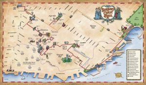
The Barbary Coast Trail is the only walking trail in SF marked with medallions, making it easy to explore San Francisco's past and present.

Affordable
For as little as ten dollars, you can tour the trail with one of our audio guides or printed guides.

Flexible
Walk the trail whenever you want, as long as you want, and as far as you want. Making it a flexible option for anyone touring the trail.
History of the
Barbary Coast Trail
The Barbary Coast Trail was first imagined in 1994 when Daniel Bacon walked The Freedom Trail in Boston and felt a compelling desire to replicate that model in his home town San Francisco. Daniel then designed a trail that would lead walkers on a journey into the city’s dynamic and storied past, all while walking through vibrant neighborhoods, each with its own history and culture.
In concert with the San Francisco Historical Society, Daniel then spent the next six years acquiring the necessary permits and raising the necessary funds to build the trail. The first 150 medallions and arrows were embedded in the sidewalk in 2000, creating a path that connects 20 of the city’s most important historic sites.
The historic sites of the Barbary Coast Trail focus primarily on the period from the Gold Rush of 1849 to the Earthquake and Fire of 1906, a time when San Francisco grew from a small village to a world-class city with the busiest port on the West Coast. There are also sites relating to the Beat period of Allen Ginsburg and Jack Kerouac.
Sites along the trail include the Old Mint, a national historic landmark; Union Square; Maiden Lane; Old St. Mary’s, first Catholic cathedral West of the Rockies; T’ien Hou temple, first Asian temple in North America; Wells Fargo History Museum; Pony Express headquarters site; Jackson Square Historic District, which contains the last cluster of Gold Rush and Barbary Coast-era buildings in San Francisco; Old Ship Saloon, once a shanghaiing den; Coit Tower; Fisherman’s Wharf; SF Maritime National Historical Park, which maintains a large collection of historic ships; and Ghirardelli Square.
Each end of the Barbary Coast Trail is connected by the Hyde-Powell cable car line, itself a national historic landmark.
The Barbary Coast Trail is a project of the San Francisco Historical Society. The Society preserves, interprets and presents the historical heritage of San Francisco from its variegated natural history to its lively human history.
